2006/08 Australia trip - Head of Bight |
|||
Saturday August 12th
Bed is the most comfortable place to watch for whales. We didn’t see any but at least we were comfortable. The wind was still strong but it was a beautiful day with a blue sky and even bluer sea.
 I managed to get down the cliff, almost down to sea level. For most of the Great Australian Bight, that wouldn’t be possible as the Perpendicular Cliffs are hundreds of feet high and either sheer or undercut by the waves, but we were camping where a stream had carved a channel down to the sea. The cliffs run for 500 miles along the Bight and must have been a terrifying sight for sailors fighting a southerly gale.
The highway stays close to the sea and we stopped often to look at the cliffs. The cliff top there has to be one of the most  dangerous places in Australia. The cliffs are limestone and heavily eroded, and undercut by the sea. The caprock is much tougher than the underlying limestone, but it’s a thin and brittle sandstone. I saw a number of places where this rock was like a diving board, sticking out six feet from the top of the cliff and only inches thick, with hundreds of feet of air underneath!
Around the Nullarbor Roadhouse, the Nullarbor Plain lives up to its name with nothing growing much above waist height, but that was only a small part of the whole Nullarbor. Perhaps the railway and the old roads went through more of that kind of country.
![]() We took the turnoff down to the coast at Head of Bight. This is where the cliffs of the west give way to a
We took the turnoff down to the coast at Head of Bight. This is where the cliffs of the west give way to a  gentler coast with miles of sand dunes to the east. The transition zone is where the southern right whales come in the winter to give birth and breed.
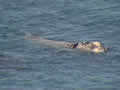
| Head of Bight whales (19.47) |
 |
|---|
There are a number of platforms along the clifftops for viewing the whales. I’d expected to be squinting out at whales a mile off, but  a couple of dozen whales were visible in the bay from the viewing platforms, with a few directly below us. They seemed to be socializing, with mothers and calves visiting each other, and a few large whales breaching, leaping out of the water. There was plenty to watch and we spent far too much time there, not leaving until the sun was close to the horizon.
The next hundred miles are in an aboriginal zone, and the only road station there, Yulata, appeared to be  dead, with all doors closed and the lights off, so we carried on in the dark. We left the aboriginal zone and
 ![]() made it to Nundroo road station and camped there on a warm evening, with the road trains thundering past. The wind had finally dropped.
made it to Nundroo road station and camped there on a warm evening, with the road trains thundering past. The wind had finally dropped.
Sunday August 13th
Sunday was sunny and cool as we set out on what was to be a driving day. A border guard searched our fridge as we entered the quarantine area at Ceduna, but we’d eaten everything of interest so there were no problems. The drive from Ceduna to Port Augusta was mainly through very flat farmland and not particularly interesting, even though there was a wide strip of bush left along the highway. We spent most of the day listening to books on CD. However, the CD player in the camper seemed to have succumbed to the dust we had earlier in the trip, so we were having to balance the computer between us and use it as a CD player.
Late in the day, after hundreds of flat miles, we spied some scenery on the horizon, but it turned out to be just an enormous heap of tailings. Nearby there was a signpost to Iron Knob so we supposed that there was a corresponding enormous ‘ole at Iron Knob. Shortly afterwards we did see some real scenery, the Flinders Ranges, a backdrop to Port Augusta, where we dived into a Big4 caravan park and asked for a site near the laundry.
We’d passed through Port Augusta in June on our way north to Alice Springs and Darwin, so we’d completed our grand loop after just over 10000 miles and nine weeks.