2006/06 Australia trip - Kings Canyon |
|||
Monday June 12th
After a cold night it was a cold and windy morning. We drove into Watarrka national park. The parking area was crowded as this was an Australian Bank Holiday, the Queens Birthday. We’d been here to Watarrka, in November 1995, when it was well over 100 degrees, and we had most of the park to ourselves. We’d set off to hike the Canyon Rim walk, but it begins with a steep natural staircase that just climbs straight from the canyon to the rim. Sandie had climbed it back then but then was so hot she went back down to recover. I did the hike, and enjoyed it but it was extremely hot that day, so I didn’t do much but follow the trail and try to stay alive.
 Overheating was unlikely to be a problem this time, as the wind was even stronger. We climbed the rock staircase and set off around the canyon rim. The rock is naturally stepped, the remains of ancient sand dunes, so the trail just goes up, over and down the landscape. Almost all the rock is red, but there is some green vegetation, a little grass, some spinifex, and cycads. The spinifex looks like a mound of grass, but the “grass” ends with needle points, very unfriendly to hikers. The cycads are like big ferns with really strong fronds. You usually see them in pictures of dinosaurs munching on the vegetation. What they are munching are cycads. They haven’t changed much in 200 million years, but one of the few places they are still found is in central Australia.
| Watarrka (11.14) | 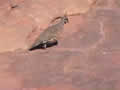 |
|---|
 The walk around the canyon rim is really spectacular, great domes of layered red rocks, like the ruins of
  some ancient city. The cliffs of the canyon are polished and sheer for hundreds of feet, so it is not a place to be careless. On one side, the cliffs have great holes seemingly chewed into the sheer face, and on the other, the cliffs are striped by patterns of iron. The picture at the top of this page shows how convoluted the scenery is: the cliff face that dominates the picture is on the other side of the canyon, and there is a sheer drop behind the round hill in the foreground.
 Since we were there last, the trails have been made safer with more guiding arrows and some stairs and bridges. The bridges made it possible to get into areas that I didn’t risk on my first visit. At the head of the canyon is the Garden of Eden, a narrow gorge with deep, cold pools and an abundance of plants.
On the trail back we met a family of spinifex pigeons, very elegant, little dove-like birds with a golden crest.  The last half of the trail rambles through more “city ruins”, and the little arrows are very important as there’s no obvious route down to the valley floor. Some of it was familiar to me though, like the sign that had a forward arrow and said “5K”. When I saw that back in 1995, I thought it meant that I still had 5K to go. As I was on a 6K walk, and I’d drunk all my water and it was way over 100 degrees with no shade, I thought I was lost and in real trouble. I turned around to see if I’d missed one of the little arrows, fell into a hole and smashed my knee. As I was groaning my way upright, I realized that I was right next to one of the emergency radio phones for summoning help – certainly a convenient place to break a leg! It wasn’t broken, but it was three years before the kneecap healed. All the parts of that drama were still there in 2006, including the stupid 5K sign, which really meant that I’d done 5K. All that’s changed is that now there’s another sign next to it that says “1K to the carpark”. Progress, of a sort.
By time we came down off the canyon rim, there wasn’t enough time to go visit anywhere else. We had a very late lunch in the parking lot, and rejoiced to find that the day’s soup was different! On the previous days we’d had soups labeled “steak”, “beef”, and “hotpot”, but we were certain they all came out of the same vat, and possibly the same cow.
One of our reasons for coming this way was for us to drive the Mereenie Road, a track that connects Watarrka with the West McDonnell Mountains. We had set out to drive this road back in 1995 as a shortcut to Alice Springs, but our rented campervan vibrated so violently on the rocky washboard that we couldn’t drive at much above walking pace. We needed to get to Alice Springs that evening, and it was quicker to drive all the way back and around on the sealed road than to take the Mereenie Road. We were also worried that we’d break it: not good when the renter forbad all travel off of sealed roads.
This time, to our surprise, the beginning of the road looked to be brand new blacktop. We stopped at the Kings Canyon Resort to ask about the road. “Yes, the first 20K is now bitumen, but don’t worry, the rest of it is still atrocious!” It seemed that we still needed a permit from the aboriginal community in order to drive the road. We couldn’t get that until the morning, so we booked into the resort’s campground.
We vegetated for a while, enjoying the sun and some very important-looking crested pigeons, and some very hungry miner  birds. I went out to watch the sunset light up Carmichael Crag, the extreme end of the George Gill mountain range. As the sun went down, hundreds of black cockatoos took off from distant trees and headed to their roosting spots somewhere nearby.