2006/05 NZ trip - White Island volcano |
|||
We had a long way to drive to Whakatane on the other side of the Bay of Plenty. The road down the east side of the Coromandel is hilly, narrow, and winding, so it was slow going for a couple of hours. The south side of the Bay of Plenty, though, is mostly flat so we even got up to the 100 kph speed limit a few times. Tauranga is the major city, and it is bypassed by an “express way”, which seemed to have speed limit of 80kph. Not very express!
All the picnic areas along this road are staffed by chickens, who demand  attention from any visitors. They don’t seem to be allied to any farmyard, so we had to assume that these were feral chickens, making their own way in life. They seem to be doing very well, and it would be ironic if the chickens survived the cats, and rats, and stoats, while New Zealand’s endemic bird populations went extinct. Obviously, New Zealanders have plenty to eat, as this source of protein would be irresistible in some countries, and the chickens would soon be in the pot.
Looking at the map, I noticed that although we had left Whitianga Harbour that morning, we were coming up on another Whitianga on the other side of the bay. There also seemed to be another Whangaparaoa, and another Muriwai! In the map books they’re distinguished by county name, but counties aren’t apparent as you are driving around, so you’d better know which one you want to visit.
After I’d looked up some of the more common Maori words, I began to understand the problem. Whanga means “bay”, wai means “water”, roto is “lake”, puke is “hill”, manga “stream” and awa is “valley”. A Maori traveling around North America would have a similar problem if the only words he could remember were “lake”, “mount”, “creek”, “river”, and “falls”. The US Post Office tries to eliminate duplicate town names but how many “Bass Lakes” are there in Minnesota?
We made good time along the south shore past Tauranga on a dark and gloomy afternoon. Now we were seeing orchards of kiwi fruit trees. The capital of the kiwi fruit industry is Te Puke (nice name!). Some orchard owners there were inspired to rename the Chinese gooseberry as the “Kiwi fruit”. This new name and the kiwi fruit’s ability to keep for months in refrigeration made those orchard owners into millionaires.
From Te Puke, the road runs along between cliffs and ocean, a fast and scenic route to Whakatane. We passed the campground and found the offices and wharf for the company and checked in for our trip out to the White Island volcano in the morning. The campground in Whakatane is not great, but it was good enough for a short stay on a dark and damp night.
Wednesday May 24th
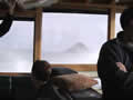
We were up before dawn to get down to the wharf for the boat trip. But first we had to pick up some crisps for Sandie. It was a calm and quiet morning, but it could be rough beyond the harbour. We boarded the Pee Jay, which was just about filled with volcano enthusiasts.
| Boat to White Island (1.57) |
 |
|---|
We had a violent exit from the harbour through the bar of the Whakatane River. Outside the harbour, it was breezy with a strong swell. As the boat was beating into the swell at 20 knots, we had a roller coaster ride, alternately lifting us off our seats and then slamming us back down. White Island is 30 miles off the coast and usually about a 90 minute ride from Whakatane, and people soon started to get sick. The guy behind Sandie went from beet red to white to green in five minutes and then his head disappeared into the bag. Sandie kept munching through a bag and a half of crisps.
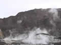
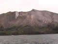
With the swell it took us two hours to get to the island. White Island didn’t look white to us even if it did to Captain Cook, who named it. From a distance it looks like a big slag heap in the ocean. On closer inspection, it looks to be a steaming slag heap, with only a few plants around the edges of the island.
| White Island (12.38) |
 |
|---|
The boat can’t get to the ancient wharf, so we had to climb down the side of the boat and jump into an inflatable dinghy and that took us to where we could climb an old ladder to the wharf. The wharf was built almost a hundred years ago, as part of a sulphur mining business. An earlier mining attempt was abandoned after a volcanic eruption and landslide blew the miners and their bunkhouses into the sea. The only survivor was one of their cats. Mining was restarted with more modern equipment but it was never really profitable and it was abandoned during the Depression.![]()
The island is the top 1000 feet of a volcano, the rest being under the Pacific Ocean. It erupts frequently, throwing out chunks of magma and jets of gas and  steam and ash. We were issued hard hats and gas masks. The masks were to protect against the ash and acidic fumes. The ash accumulates in your lungs as concrete, and the acid collects on the back of your throat and makes you cough!
![]() Despite all the dangers and drawbacks, the island is a very
Despite all the dangers and drawbacks, the island is a very interesting spot, if you’re a volcano fan. It’s rare to be able to walk through a volcanic crater without having to climb a mountain first! Our guide Andy took us through the crater, visiting sulphur crystals, fumaroles, the boiling lake, the bubbling mud pots, and finally the old sulphur factory, which is decaying fast in the corrosive atmosphere. The wood beams are doing well, but the iron in the concrete is corroding and splitting the walls apart.
Back on the boat, the Pee Jay crew served a great lunch.
| Return from White Island (4.42) |
 |
|---|
The trip back was easier with a following swell, but still tough for a few people. Most of the rest of us fell asleep.
Next