2006/03 Southwest USA trip (AZ-MN) - Great Salt Plains Lake |
|||
Tuesday February 28th
We had another warm, sunny morning for a long drive out of Texas and into Oklahoma. We passed the town of Gene Autry which renamed itself when the cowboy star came to live there. He died a few years back at 90-something, a very rich man. By afternoon we had passed through Oklahoma City and were on our way northwest to the Great Salt Plains Lake. This part of Oklahoma is absolutely flat, and for forty miles every field seemed to have the same two dozen black cows eating the same stubble. Then we saw a great expanse of water and knew we’d made it to the lake.

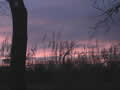
The state park seemed to ramble along the shore line, with dozens of campsites, and it must be a popular  spot in the summer. We saw a couple of tents but otherwise seemed to have the lake to ourselves. We found a copse of trees right on the beach, a campsite to fight over in the summer, and popped in there just in time to watch the strangest and most spectacular sunset of the trip. The light over the lake was unearthly, and the red of the sky made it look like a lake of blood.
| Great Salt Plains Lake (1.09) |
 |
|---|
 Wednesday March 1st
It was already hot at dawn, and looked likely to be another 80 degree day, very warm for that time of the year. We could see by daylight that the lake was a reservoir, presumably drowning a part of the “great salt plains”. The lake didn’t taste very good but it wasn’t particularly salty. The trails across the red earth though were streaked with white, an indication of some kind of salt on the ground. Presumably this was gypsum salt.

We drove to the nearby wildlife reserve, and walked and drove some of its trails. It certainly had plenty of  wildlife: we saw a bald eagle, a pair of deer, a flock of pelicans, and innumerable ducks and geese. The reserve is actively managed The staff raise and lower pond levels to maximize the food available at critical times and they plant the surrounding fields with crops chosen to feed the migrating flocks.
 The west end of the reserve shows what the land was like before the dam: thousands of acres covered with gypsum and common salt. Very little vegetation grows, but it’s still a popular resting spot for millions of migrating birds.
It’s also a spot for finding big crystals of selenite. This is a kind of gypsum found a few inches below the  surface. The digging season doesn’t start until April, but we found a few pieces of crystal on the trails.
This area of Oklahoma is known affectionately as “Tornado Alley”. A gigantic “F5” tornado came through just south of here a few years back and did a lot of damage to Tinker Air Force Base. It came close to wiping out their computer installation, and this generated a lot of revenue for my employer, as the Air Force decided to duplicate all of its computers and put them in another site, away from Tornado Alley. On our way out we passed the little town of Wakita, the place that was flattened in the “Twister” movie. Although we didn’t know it at the time we were only a week away from the first tornadoes of the season.