2004/08 Yukon trip - The road home - |
|||||
Monday 6th September
We had a sunny morning as we drove north along the North Thompson River road. There are few towns on this road and most have just a single street, often with closed restaurants and businesses. There is little traffic on the road even in summer, so it’s difficult for businesses to make it. There is plenty of scenery though with the river and the mountains. The peaks were getting steadily higher with more snow as we moved north.
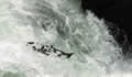
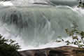 We turned east onto the Yellowhead Highway, which parallels the first twenty miles of the Fraser River. We walked down to Rearguard Falls to watch the salmon climbing the falls. These salmon had swum 800 miles upriver from the sea at Vancouver, a great journey through Hope, the fish ladder at Hells Gate, Prince George, and then the whitewater of the upper river. After all that I could forgive them for not jumping high enough out of the river for me to get a clear picture. Luckily for them, Rearguard is more of a cascade than a falls. It’s still impressive though as we could get really close to those great green billows of water. Not as exciting as going through them on a raft, but a fair bit safer!
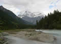
From here on we had great views of Mount Robson. The mountain top is usually hidden by clouds and, sure enough, it eventually disappeared while we were watching. At dusk we were still in the Mount Robson provincial park so we stayed at the Robson Meadows campground, a short walk from the Fraser. It was a quiet spot at the end of the holiday weekend. We cooked bratwurst over the fire on a warm drizzly evening.
 Tuesday 7th September
I had intended taking an early morning run along the river to Overlander Falls, but I woke up with coughing and aching all over so I stayed in bed. The conclusion was that I’d caught Karen’s cold. My marathon training was not going very well. We made a late start and soon stopped to take the short walk to the falls. Overlander is the limit for the salmon as they can’t get up this falls. We passed the headwaters of the Fraser River, crossed Yellowhead Pass, and entered Alberta and Jasper National Park. The national park employees were on strike and nearly all the campgrounds and facilities were closed, but they still managed to staff the entrance station and collect the fees for entering the park!
| Icefields Parkway - Jasper (Athabasca Falls, Sunwapta Falls ) and Banff (Peyto Lake, Bow Lake) |
|---|
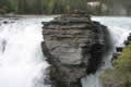
We drove down the Icefields Parkway, stopping off for a quick look at all the waterfalls: Athabasca, Sunwapta, and Tangle. They were all much smaller than when we’d seen them before in early summer, but they were still pretty and there were very few people there. Almost all the mountains had a fresh layer of snow, so it was more scenic than the summer view. The only place left to camp was the overflow lot at the Icefields, so we camped there, on the blacktop, with a great view of the Athabasca Glacier where it flows down from the Columbia Icefield and Superman’s home. On our first trip here in the early ‘80s 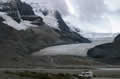 we saw parts of the Superman movie set being transported up the glacier on a big snowmobile truck. That was in the days when tourists were transported in a couple of small tinny-looking snowmobiles. Today there is a fleet of giant glacier buses to handle the thousands of visitors.
Wednesday 8th September
Cold, wet, and windy describes the night and the morning, about what we deserved for camping next to an icefield. For added excitement the furnace had stopped working again and required adjustment in the early hours. My cold had got worse, and Sandie was having earache from the ups and downs and the cold weather. 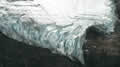
But we still wanted to take a look, so we drove to the glacier’s parking lot at the foot of the moraine. In the early ![]() 80s this is where the glacier ended, but now to see the glacier you have to climb up over the moraine and walk a hundred yards to see the end. I think it’s retreated a little since we were last here with John and Edna, but it’s hard to tell as the park service has reworked the access trail. This time most of the glacier was roped off, and we could only walk up on the ice between two rows of cones. Presumably this is to avoid the “tourist in the crevasse” problem. I took one step on the steep wet ice and decided that I didn’t want to walk up the glacier anyway. I’ll only do that if I have a pair of sharp crampons and an ice axe!
80s this is where the glacier ended, but now to see the glacier you have to climb up over the moraine and walk a hundred yards to see the end. I think it’s retreated a little since we were last here with John and Edna, but it’s hard to tell as the park service has reworked the access trail. This time most of the glacier was roped off, and we could only walk up on the ice between two rows of cones. Presumably this is to avoid the “tourist in the crevasse” problem. I took one step on the steep wet ice and decided that I didn’t want to walk up the glacier anyway. I’ll only do that if I have a pair of sharp crampons and an ice axe!
 For the rest of the day we drove the Icefields Parkway past Saskatchewan Crossing south to Lake
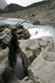 Louise. This drive is always beautiful. On this day it was always raining but not enough that we couldn’t see the mountains, so it was ideal for photography but a bit damp for hiking. As well as the usual sights, we stumbled into some others that we hadn’t seen before.
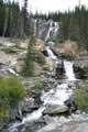
 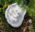 While we were turning around to go back and look at a waterfall, Sandie noticed that the stream from the waterfall just disappeared into the ground. Further examination showed that it dropped maybe a hundred feet into a narrow canyon, just a slot in the ground, an underground waterfall. It looks like this was once a place for people to stop and look and picnic, but now the parks service makes it
 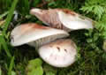 hard to see it at all. Our guess is that they’ve given up on making it safe: to see anything you have to climb around the canyon rim, so it’s easier for them to just hide it.
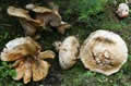
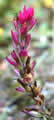
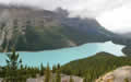
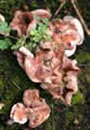
We stopped at Peyto Lake, always a beautiful view if you can take the climb up the trail to the lookout. This time I also found the 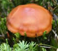 old trail with its lookout, just a bit different from the usual view. The big surprise was the fungi around the trail, great colonies of
 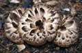 colourful mushrooms and toadstools. There were even mixed colonies, different types apparently living in harmony, though I suppose there were great fungi wars going on below the surface.
Our last stop was at Bow Lake, a great blue-green lake surrounded by triangular mountains with glaciers nestled around 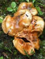
 the peaks. I’ve always wanted to hike up to the high waterfall that drops from the Bow Glacier but on previous attempts we’ve either run out of time or run into bad weather. This time we were running out of light. We joined the TransCanada Highway and passed Lake Louise and Banff. We were having trouble looking for a campsite outside the park, as we were either in ranching country or the Stoney Indian Reserve. Neither community welcomes campers, and many of the side roads are in use by the oil companies. We had a long drive through fog and dark on a gravel roads
 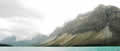 with some panic stops to dodge vagrant cows. Finally, Sandie spotted a picnic area in Kananaskis that turned out to be an ideal site for us.