2004/08 Yukon trip - The road home - |
|||||
We returned to the Campbell Highway, heading east. It narrowed until we were driving a lonely corridor through the forest. After about 30 miles, we took the side road to Ross River as we had to buy gas in order to make it to Watson Lake, but the gas station cum general store was closed for lunch, and so was the rest of town. Not really having any choice, we decided we might as well have lunch too.
Ross River’s moment of glory happened during the war when the Canol Road was built to connect Whitehorse with the oilfields at Norman Wells in the Northwest Territory. The war ended and the road was never used for its intended purpose. The equipment used in its construction was just abandoned so there is a massive graveyard of 1940s trucks and bulldozers somewhere out towards its end point. The road is still open as far as the NWT border and it is used by prospectors and adventurers, but we saved its exploration for another future trip.
As we came into Ross River there was a sign saying “Welcome to Ross River” alongside one of the ancient WW2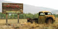 trucks. If the sign had been bright and colorful, then it might have sent a good message, but a derelict sign next to a derelict truck definitely sent the wrong message! Amazingly, Ross River had a paved street and elegant concrete streetlights as if we were coming into a big city. It also had a few large imposing government buildings. Everything else looked closed or run down.
We had lunch down by the ferry (which led across the Pelly River to the Canol Road), and that was also closed for lunch. I walked over the suspension footbridge and it reminded me of the Crazy House at the fair, as it began with a fifteen degree list to the right and halfway across leaned to the left. There were more nails out than in, and I was glad I was crossing the river on a balmy August day rather than in a November gale. After November, of course, I could just walk across the ice.