2004/07 Yukon trip - Trek to the Arctic - |
|||||
We retraced our steps back to Jakes Corner in the Yukon and then headed south on the Taglish Road to Carcross. We had some excitement at the roadworks on the way there. According to the flag lady, we were supposed to be threading our way between the big road building machines. We were following a couple on a Harley, when they took off up a dirt ramp. Thinking that they had instructions from the flag lady to do this, we followed them, and found ourselves in a roadless and tilted wasteland shared with a big bulldozer. We crossed the wasteland with care, and the ‘dozer driver was kind enough to carve a flat bit so that we could get back on the road. Back on the road, things weren’t much better. The road was extremely dusty, very hard to see anything when we met another car.
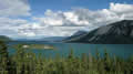
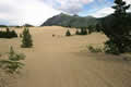 Carcross is short for Caribou Crossing, which is what happens every year here where there is a narrows between two big lakes, Tagish and Wheaton. Carcross is also famous for its tiny desert. This is the bed of a dried-up lake. The wind whistling down from White Pass stops most plants from getting a hold, so there’s about a square mile of bare sand dunes.
From Carcross it’s a steady climb up to White Pass, past enormous icy lakes and the town of Fraser, the most 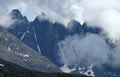 north-westerly community in BC, into a desolate area of rock and water and ice. The pass is only at about 3000 feet, but because it’s so far north, the rocks only support lichens and a few stunted trees.
The Canadian and American border stations are about 10 miles apart, so there’s a no man’s land in between, where nobody wants to work. We crossed into the USA with annoying mild harassment from the border guard, who deserves his current posting halfway up a mountain, and descended to the seaside. We were headed for Skagway, but it was late and we changed direction to the extinct town of Dyea, which has free camping. The road to Dyea is about a car and a half wide and winds around the mountains just above the sea, so not too many motorhomes make it out there. However, the state park campground was full, so we headed for Dyea Flats, a floodplain zone where nobody seems to mind your camping anywhere.
| Skagway, Dyea, and White Pass Road, White Pass and Yukon Route |
|---|
Dyea was the base for the Chilkoot Trail, where the miners used to set off for the Klondike, 600 miles north. 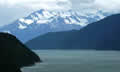 Skagway was its competitor, with the White Pass Trail. When the railroad was built to White Pass, Dyea just died, and doesn’t exist today. Our campsite was great with a view down the estuary of the Taiya River, with mountains and glaciers on all sides. The only drawback was our proximity to Alaska Dog Sled Adventures who have a large number of sled dogs. There was lots of howling and barking coming from the other side of the valley.
 Sunday 25th July
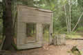
We took a look at the ruins of Dyea. As you’d expect, a tent and log cabin city easily 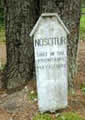 disappears, so there are only a few traces: a line of planted trees, one storefront, holes that were once cellars, and pieces of iron machinery. The cemetery mainly had crosses for victims from a single snow avalanche that killed a lot of people just below the Chilkoot Pass on April 3rd 1898. There was one headstone, though, that just said “unknown” and “shot in the mountains”.
There was no gold in either Dyea or Skagway. These were just places to unload from a ship and begin the 600 mile trip across the Yukon to Dawson City and the Klondike River. The gold was in the Eldorado and Bonanza Creeks that fed the Klondike. The border between Alaska and Canada was in dispute at the time. The Canadians settled the dispute by installing a detachment of Northwest Mounted Police at White Pass and the Chilkoot Pass. There is still some resentment today, a feeling that the Canadians put one over on the USA. Once they were in, the NWMP insisted that all miners had at least a ton of goods to keep them alive in the Yukon. Then, of course, they hit them with import duty on those goods!
Skagway has a lot of Klondike history, and it has been recreated mainly to serve as a shopping area for people coming off the Alaska cruise ships. It has about 700 residents and some days has 10000 visitors. We had some shopping to do for a wedding present, so we joined the masses, and enjoyed our shopping day in Skagway. There are plenty of shops selling expensive souvenirs, but very few restaurants, as the visitors are very well fed on the ships. Once the cruise ships were ready to depart, the town virtually closed down.
| Skagway & Dyea (7.54) |
 |
|---|
We visited the gold rush cemetery. The most notorious resident is “Soapy Smith”, the gangster who ran the town back in the Klondike days. He has a grave outside the cemetery in unconsecrated ground. The most famous hero is Frank Reid, the town’s surveyor, who shot Soapy, but also died in the battle. His fancy tombstone reads “He gave his life for the honour of the town.” There’s also a stone for a murdered prostitute who supposedly “Gave her honour for the life of the town.”
 We were back camping on Dyea Flats, this time with a closer view of the Taiya River, and a bit further away from the dogs. They were the power behind “Alaskan Sled Dog Advenfures”. Late in the evening a sled dog team came roaring past us with a dozen dogs pulling a metal wagon full of kids, everyone having a good time. I’d hoped to take a picture on their next circuit, but they wiped out on the ripples and didn’t come around again.