2004/06 Yukon trip - Getting there - Telegraph Creek |
|||||
Monday 19th July
We made it to Dease Lake in the morning, and then decided to see what was so bad about this road to Telegraph Creek, about a 70 mile drive from Dease Lake.
At first it was just a poor dirt road, about 50 miles of bumps and holes through a spruce and alder forest, but then wow. Two rivers, the Tahlton and the Stikine, come together at the Tahlton Indian village. 
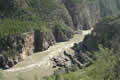
 The rock there is all volcanic and twisted and eroded, and both rivers have dramatic canyons. The two canyons come together at a sharp angle. The road improbably dives straight down the cliff at this meeting point, crosses the Tahlton River and then climbs diagonally up the canyon wall of the Stikine River. The road is a car and a half wide with a 20% grade and a steep drop into one or the other rivers. We agreed that it was breathtaking scenery, but it was not particularly scary.
 We followed the road to Telegraph Creek, a tiny village perched on the walls of the Stikine Canyon. We treated ourselves to lunch at the lodge, with the excuse that it was the only place to park, though as half the houses are ruins there are plenty of spare driveways. There were great plans for Telegraph Creek, but it turned out to be just too hard to get to. Today their main business is tourism, especially rafting down the Stikine to Wrangell in Alaska, about a $2000 trip. Each!
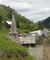
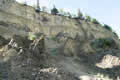
On our way back we got a better look at the road and could see why the Tiger driver thought it scary. The whole canyon wall is rotten and the road is just a bulldozed ledge covered in gravel. I don’t know whether the bigger danger is falling off it or through it or being hit by stuff falling on it. I walked back up it to take some pictures and the whole time I could hear rocks sliding and falling around me. However, like most people we got away with it, and we were glad we’d made the trip and seen the really awesome scenery.
![]() We still had 50 miles to bounce back to Dease Lake and look for a campsite. This wasn’t easy as nobody advertises the free campsites. The Chambers of Commerce information signs for these little towns only show the commercial campgrounds, and of course the locals prefer to keep the free ones for themselves. We found a forestry service campground at Sawmill Point on Dease Lake, just north of the Rabid Grizzly rest area. (Yes, really! Sounds more threatening than Australia’s rabid possums.) The best spots along the lake were taken but we camped along a little stream in the woods.
We still had 50 miles to bounce back to Dease Lake and look for a campsite. This wasn’t easy as nobody advertises the free campsites. The Chambers of Commerce information signs for these little towns only show the commercial campgrounds, and of course the locals prefer to keep the free ones for themselves. We found a forestry service campground at Sawmill Point on Dease Lake, just north of the Rabid Grizzly rest area. (Yes, really! Sounds more threatening than Australia’s rabid possums.) The best spots along the lake were taken but we camped along a little stream in the woods.