2004/06 Yukon trip - Getting there - 'Ksan and Hazeltons |
|||||
 We retraced our steps along the Yellowhead Highway towards Hazelton. This took us through Moricetown,
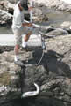 an Indian village situated where the Bulkley River drops into the narrow Moricetown Canyon. The Indians take full advantage of this and they perch on the top of the falls with nets and gaffs to catch the chum salmon as they fight their way up the falls.
| Moricetown (1.12) | 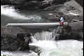 |
|---|
The Hazeltons (Old, New, and South) are also Indian villages, with the original Old Hazelton famous for its re-created Gitksan Village, called ‘Ksan. The village has a recreation of the long houses and the totems. We took the guided tour as that was the only way to see inside the long houses, most of which contain the Indian’s clan properties, like canoes, dancing shawls, baskets, weapons, and bent-wood boxes, an amazing diversity of art. 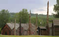
 Our guide was Sheri of the Frog clan, but most of the explanations inside the houses were prerecorded performances. All this time, the sky was getting darker over the mountains and the thunder was rolling in.
Old Hazelton itself is a recreation of the original town back when it was a supply point for the gold miners, but it didn’t look too appealing to us so we moved on.
We had one more stop at Kispiox, another Indian village, this one famous for its field of totems. Our plan was to quietly view and photograph their totems but the whole village was having a party in the totem field! There were kids climbing totems and football games going on using poles as goalposts, but they didn’t seem to mind us being there.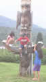
We planned to camp at Bell Lake forest service campground off of the “Kitwanga back road” though the locals seemed surprised that we even knew about it. The sign said “Open at 15.5K”. We found out why: at 15.5K that part of the road is on a rock slide, where the whole mountain is sliding into the Skeena River. We bounced across the rocks on their latest attempt at a road. Chances are that a few days of rain will close the road again. On the other side of the slide, we interpreted the twig balanced on a rock as a road sign, took the turn and climbed very steeply on a single track road. We ended up at Keynton Lake. We were the only people there, so we camped on the beach. The lake had mountains, loons, fish jumping, and free firewood. It wasn’t the right lake, but why should we care?
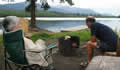
The thunderstorms rolled though and gave us some showers, but we were able to cook dinner over the fire. We had satellite phone reception at the end of the dock so Sandie and Karen were able to continue their knitting discussions.