2004/04 Boston and South Carolina trip - Tahquamenon Falls |
|||
 Monday April 12th
We headed east across Michigan’s upper peninsula. People who live here are called UP-pers, pronounced “youpers”, a very independent bunch. We skirted Baraga Bay, named after Bishop Baraga who ministered to the local Indians a couple of hundred years ago. The bay was still frozen even though the main body of the lake was open water. We took a quick (and free, as it was officially closed) look at the Baraga monument at the top of the hill inside the Indian reservation.
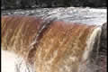
All the parks and campgrounds across Michigan were still closed too. We were headed  for Tahquamenon Falls, the biggest and most popular waterfall in Michigan. We trudged through deep snow to the upper falls. These are at a big step in the river, a uniform wall of tannin-stained water from bank to bank.
The road to the lower falls was closed to vehicles, so we had a long walk through the  snow down to the falls and back. The river splits there around some islands into a number of cascades that drop into a lake. In the summer it would be a great spot for canoeing, but in the spring it is both spectacular and lethal.
| Tahquamenon Falls (9.52) |
 |
|---|
 The campground was open! At least a few campsites were. Enough snow had been ploughed out for us to get the truck in, but we were surrounded by knee-deep drifts. This made cooking a little difficult as the picnic table was half buried.
It was a peaceful night as there was only one other camper. We’d met him earlier on the trail and he was disgusted that the Michigan state parks people had told him that he didn’t need to bring his snowshoes! This was a little warmer than our last site, somewhere in the twenties overnight, but it was cold under the shade of the pine trees in the morning.