2004/03 Tasmania loop - Narawntapu |
|||
 Saturday March 27th
It was a cold night, with heavy dew, and we took our time waiting for the sun to get over the mountains the next morning. We weren’t going very far, just to a park that would be close to Devonport’s ferry terminal on the following day. We went north through the tin mining area around Derby and stopped for lunch at the Forestry Tasmania tea rooms in Scottsdale. It seems odd to go and eat in an office building, but the place seems to be very popular with the locals.
We took a scenic route across the mountains. It certainly wasn’t the shortest, as somehow we’d ended up on logging roads, and got to see a lot of trees. I’d left the GPS behind in Melbourne, but it isn’t too difficult to navigate your way out as long as the sun is shining.
We found the Tamar River, drove up the east bank, and crossed at the Batman Bridge. Yes, we did the doo-dee-doo tune on the way across, even though we’re a long way from Gotham City. We drove back down the west bank and then took a lonely dirt road along the edge of the Asbestos Range. This used to be the name of the park, but I guess it deterred visitors and it’s been changed to Narawntapu.
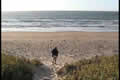
 The park is at the mouth of the Rubicon River, so it has both a beach and a stretch of river.
  Behind the dunes are some fresh water lagoons and some scrubby forest. It is a great place to see wildlife. There are pademelons, wallabies, native hens, wombats, and possums all around the campground, and we saw some kangaroos off in the distance. The lagoon had coots and ducks and geese, while the shore had all the usual seabirds.
| Narawntapu (4.02) |
 |
|---|
Sunday March 28th
It was only three weeks to the Boston Marathon, so I had to step up the training, and I took a three hour run along the beach and up the river bank. The tide was out a long way. I had to make a couple of detours to get around more crowds of tiny crabs.