2004/03 Tasmania loop - Freycinet and Wineglass Bay |
|||
We hurried off after breakfast and were first in line for the ferry over to Kettering. We had a  quick transit through Hobart and then stopped in Sorell on the Tasman Highway. This is a nice little town and we remembered where most things were from our last trip. We stocked up on all the essentials: diesel, propane, food, cash, rum, lunch, and the Internet. Sandie also got directions on where to go fossicking up in the northeast corner of the island.
We resisted the temptation to revisit the Tasman Peninsula and its spectacular cliffs. We wanted to see new areas, so we headed up the east coast, a nice drive through the hills via Black Man’s Opening and Break Your Neck Hill. This was largely sheep and cattle ranching country. We passed Maria’s Island, another national park, a big chunk of granite poking out of the sea.
![]() Finally we spotted a range of mountains across the bay. This was Freycinet National Park, though it was another hour’s driving to get to the peninsula
Finally we spotted a range of mountains across the bay. This was Freycinet National Park, though it was another hour’s driving to get to the peninsula  and drive down it to the park. When we got there we found that all the campsites were taken, and we had to retrace our steps for twenty miles and camp on the Friendly Beaches, another free camp site. We found a great spot just above the rocks with a view of the bay, and crashing waves for a lullaby. As soon as we set up we were met by the Welcome Wallaby who hopped around to the back of the camper and decided to stay for dinner.
We’d traveled a few hundred miles north from Bruny Island and it was definitely getting warmer, but still too breezy and cool to sit outside. We weren’t getting much use out of those new chairs.
 Thursday March 25th
Next morning the Presiding Pademelon also joined us for breakfast. This beach had yet more hooded plovers. Either they weren’t as rare, or they were traveling with us.
We drove into Coles Bay on the edge of the park and intended getting one of the prime campsites in the main campground. But we ended up looking at things and forgot all about the campsite.
 |
|---|

We drove up to the Cape Tourville overlook and the lighthouse, and then  hiked down to Little Gravelly Beach. Some of the bigger rocks there are eroded to the point where they are almost hollow.
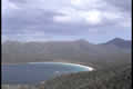
We decided to hike the trail over to Wineglass Bay, which is one of those internationally known hikes that everyone has to do. The trail goes up to the saddle between granite mountains Amos and Mayson, and leads to a platform overlooking the bay. It was very windy on the saddle. From the platform Wineglass Bay did look very inviting, deep blue water, white sand, green forest, and a  backdrop of mountains.
Unfortunately a whole bus-load of French students arrived just afterwards and went through all the possible combinations of photographic groups and poses against the backdrop of the bay. We discussed the weight tolerances of the platform, but unfortunately it held up under the load. Sandie didn’t want to hike down and up again, so she waited until the crowd left to take her pictures, and I headed down the trail to the bay.

Down there it was just as beautiful with red rocks and white sand against the blue water and sky. The climb back up was a solid grind though, about a thousand rough steps, so I could see why more people view the bay than actually visit it. There were a few boats anchored in the bay, following the lead of Queen Elizabeth who picnicked here from her Royal Yacht. I would imagine that the Queen wore more clothes than the people on the boats.

We went to the waterfront in Coles Bay to get a view of the mountains and there the wind was driving the waves over the pier. However, all was calm back at the Friendly Beaches on the other coast.
 Friday March 26th
That morning I ran along the beach as far as I could, almost to the lighthouse we’d seen the previous day. The sand is from eroded granite, and it squeaks when dry, so I went squeak-squeak-squeak for a couple of hours.