2004/03 Tasmania loop - South Bruny Island |
|||
We stopped off at Geeveston for shopping and Internet access, and that’s when we heard that our friend Maynard Magnuson’s chaemotherapy treatment had gone bad, and that he was giving up on the treatment and going onto hospice.
We were heading for the 5 pm ferry to Bruny Island, but, like most roads in Tasmania, this one wandered all over the place, and we were definitely late. Luckily, so was the ferry, and they reopened the gates to let us on, and saved us from a two hour wait. It was a fifteen minute ride across to the island, and then a long drive to our destination.
The north part of the island is agricultural and connected to the more forested south part by a long isthmus called the Neck. The Neck is battered by Pacific rollers on one side, but has a placid lagoon on the other.
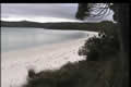
 The Bruny Island national park occupies the southern tips of a number of headlands on the south part of the island. We passed the Cape Bruny lighthouse and headed down a narrow lane to the campground at Jetty Cove. Our campsite was in the woods but overlooking the bay. It was free, probably too remote for anyone to bother collecting the money.
 The beach faced north well away from the wind and waves, and it was dead
![]() calm. There were more hooded plovers on the beach. The sun set behind the ridge, but lit up the clouds over our heads into a blazing red flag.
calm. There were more hooded plovers on the beach. The sun set behind the ridge, but lit up the clouds over our heads into a blazing red flag.
| Bruny Island (9.07) |
 |
|---|
Tuesday March 23rd
It was still calm in the morning. The beach used to have a jetty for provisioning the lighthouse. It was obviously a good choice, but it would have been a long haul to get the provisions up and over the hills to the lighthouse.
That’s where we were headed. The lighthouse was under repair so we couldn’t look inside. It’s in a bleak spot, but it had a great view of the volcanic cliffs and the surging sea. There’s nothing between here and the Antarctic, so the weather must get pretty wild at times.