2004/03 Tasmania loop - Stanley and Marrawah |
|||
 Later, we set off for Stanley. We passed a long, high pier on our way in and remarked on how similar it was to the piers at Silver Bay on Lake Superior. Sure enough, it’s for loading taconite (iron ore) into ships. The ore is mined in the interior and then shot fifty miles down tubes to the coast.
 We took the grand driving tour around Stanley, which is on a very thin peninsula that connects the Nut to the mainland. It has some grand old colonial buildings as well as the usual prison ruin. We Brits had this thing about locating prisons on islands, and Tasmania ended up with lots of them, usually in desolate spots with very undesirable climates.
There were lots of information signs posted by the “Circular Head” Council. Circular Head was the original name for the Nut, given by the British explorers, and the local politicians readopted it as they probably didn’t want to be known as the Nut Council.
| Stanley's Nut (6.45) | 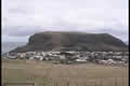 |
|---|

There was a chair lift up to the top of the Nut, but we bravely decided to walk up the track instead. The farmers must have been pretty tough back then as they used to live at the bottom and tend their fields on top of the Nut. We guessed that they probably rolled their potatoes down the hill.
We walked the Nut perimeter, and there were great views in all directions, but it was blowing so hard up there that we had trouble standing and looking at them. They also have another export from Britain: gorse. Hiking through gorse bushes on a windy day can be painful!
![]()
We were going to be camping over on the West Coast, and we headed to  the little hamlet of Marrawah and the beach at Green Point. It was even windier there and we had to position the camper so that it was facing into the wind. Violent rain squalls were piling the rainwater up on one side of the roof and blowing it in the vents.
Despite the weather, it was a great campsite, just above the bay, with massive rocky heads in each direction. We’d been expecting that kind of weather anyway. As mentioned earlier, Tasmania sits squarely in the Roaring Forties and the next piece of land to the west is South America, about 8000 miles away, so the wind and waves have plenty of time to build up. They’ve recorded sixty foot waves on this coast. There are a few little places hidden away in protected harbours and river mouths, but there are no towns actually on the west coast.
| Northwest coast (12.58) |
 |
|---|
 Green Point’s beach seems to be popular with the surfers, judging from the art on the toilets.
I went for a walk along the beach, tacking into the wind, and realized that the rain was a blessing. Whenever the topmost layer of sand got dry, it would be picked up by the wind and flung down the beach. The light dry sand swirling over the dark wet sand was beautiful to watch but tough to photograph. And even tougher on the calves and bare feet!