1995/11 Australia trip - Watarrka |
|||
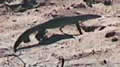
![]() Sunday morning we were up early enough to see a beautiful sunrise across the campground and then we were off east and then north to Watarrka national park and Kings Canyon. On the way we saw one of the big red kangaroos on the road but thought it was a cow until we got close, so got no pictures. We also saw a couple of lizards, including a perentie which was maybe 3-4 feet long, about half the size they can grow to. This road was even quieter than the others, as it only leads to the park which doesn’t receive nearly as many visitors as Uluru.
Sunday morning we were up early enough to see a beautiful sunrise across the campground and then we were off east and then north to Watarrka national park and Kings Canyon. On the way we saw one of the big red kangaroos on the road but thought it was a cow until we got close, so got no pictures. We also saw a couple of lizards, including a perentie which was maybe 3-4 feet long, about half the size they can grow to. This road was even quieter than the others, as it only leads to the park which doesn’t receive nearly as many visitors as Uluru.
 |
|---|

The canyon was well worth the drive, all red rock, yellow grasses, and green trees, similar in many ways to Zion Canyon in Utah, including the temperature. By the time we got there it was about noon, and well over 100. There was a bus-load of tourists squeezed into the shade of the information booth and entertaining the flies, and they made some remarks about mad dogs and Englishmen. I was tempted to ask them if they were having fun yet, but kept going as we’d decided we’d put up with the heat. As we were walking across the valley floor, I’d noticed this odd rock formation in the cliff wall, and sure enough it turned out to be the way up. No messing around with switchbacks here. Instead, they’d just built a staircase in rock up the cliff, taking advantage of the rock’s layering.

Sandie made it to the top, and got to see the view, but she was red-faced and gasping a little, so she decided not to hike the canyon rim, and went back to the camper to get a little sleep. This was probably just as well as there was no real trail, just the occasional arrow pointing to the next pile of rocks to climb over. The rock was in layers, so it was safe climbing, but tough going in the heat, as it was really convoluted country, rather like our Badlands.
I got lost a few times and had to backtrack, but the little arrows worked when I could find them. I just wish that they’d put the distance to go on their signposts instead of the distance done. After two hours of hiking and using nearly all my water, I thought I was nearly done, but I found this signpost saying 5k. I was so surprised that I spun around to see if I’d got off the track, the rock I was on tilted, and I fell into a hole. Nothing was broken, but even if it had been, I’d have probably survived as I’d crashed right next to an emergency radio on a pole. There’s only one ranger station for an enormous area, so the radios are a good idea.

Surprisingly, there were a few pools of water up there on the rim, and also some really strange shrubs called cycads, which are like palm trees without the trunk. These are the sort of trees you see in dinosaur pictures. In most parts of the world they have died out, but here they have survived in isolation.
| Watarrka (Kings Canyon) (13.10) |
 |
|---|
After the hike, we had planned to drive the Mereenie Road, which crosses aboriginal land and ends up at the west end of the McDonnell mountain range. We had even got our permit to cross, but after a mile or so we realised that 150 miles of that kind of shaking would probably shake the fillings out of our teeth, not to mention what would happen to the camper. It was really what I call a rock road: bulldozed into flattish surface, but no gravel to fill in the holes. So we admitted defeat and took the only surfaced road, which was over twice as far. Luckily, there are no speed limits in the Northern Territory, but wandering cows tend to make you cautious, so it was, as usual, dark when we rolled into a campground just outside Alice Springs.