1987/04 Monterey - Big Sur coastal scenery |
|||||
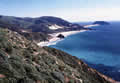
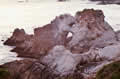
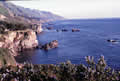
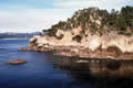
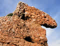
The rest of these pictures show the highly variable scenery of the Big Sur Highway between Point Lobos and Jules Pfeiffer state park.
  |
|
  |
|
  |
.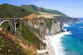
Even the road and its bridges are scenic. This is the Bixby Bridge at Big Sur.
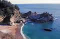 I turned around about 20 miles south of there I believe, at Julia Pfeiffer state park, where McWay Falls drops from the cliffs onto the beach.
. What surprises me is that I have no close-up pictures of the waterfall from the beach. Nor do I remember actually going down to the beach. Perhaps the path down was gated.
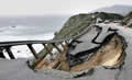
I found this Internet picture of one of the washouts that plague the Big Sur Highway. The soil is sandy and the road has been the victim of flood, fire, and earthquakes, and is sometimes closed for over a year.
Back in 1984 I tried to drive over the mountains from Pinnacles national monument to Big Sur, not realizing that the road had been severed in three places.
 I haven’t been back to the Big Sur area since this trip to Monterey.
 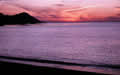 One of the surprising features of my trip had been the light traffic, unusual for California. Now (in 2024) there is much discussion of solving the parking problems at the scenic overlooks and “selfie” spots . There was even talk of introducing a reservation system for people wanting to walk the trails of Point Lobos. Perhaps I’d rather not visit the area again unless there’s an off-season without the crowds.