1983/04 Yosemite trip - Yosemite Valley |
|||||||
Yosemite Valley |
|||||||
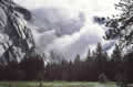
 And so the night progressed until I awoke to see that the night had turned grey. I wasn’t likely to get any more sleep, so I got up, quickly as I was already dressed for hiking. On my way down to the car I noticed the cafeteria, not yet open, but it would be good for an evening meal. The good news was that the snow had stopped at about knee-deep and the sky was clearing. The bad news was that the build up of snow had blocked the drainage from the parking lot and my rental car was sitting in the middle of a lake, with water up to the doors. I had little choice but to wade through it. I was wondering how good my boots’ waterproofing was when the water came over the tops and I ceased to worry. Another couple of soggy steps and the sun came out and lit up the cliffs. Every ledge on the cliffs was full of fresh snow and the sight was dazzling and breathtaking. I’d never seen mountains look so beautiful. Although I was standing there in the water, I had to take some pictures, but no camera could capture that light, not even Ansel Adams’.
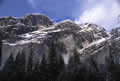
 Yosemite owes its unique scenery to a combination of granite and glaciers. It is part of the Sierra Nevada, a mountain range that began as a gigantic pocket of magma that solidified into granite deep in the earth under great pressure from the layers above. Over millions of years the layers eroded away leaving the granite exposed. Without the pressure the granite buckled and cracked, giving rise to the area’s distinctive domes. The erosion pattern is called exfoliation and has been likened to an onion skin, except that the pieces which break off can be hundreds of yards wide and weigh hundreds of thousands of tons.
During the ice ages the entire mountain range was glaciated and the Merced River valley was ground down into a bathtub shape, with vertical cliffs thousands of feet deep. This was  when Half Dome’s other half was ground off. When the glacier receded and disappeared, the streams that fed the Merced River now dropped thousands of feet in spectacular waterfalls to the valley floor. These waterfalls can dry up in summer when all the snow is gone from the high country but they are at their best in springtime.
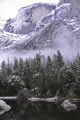
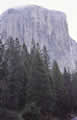
I set off to travel around the views and sights of the valley. This was before the days of the shuttles, so I was able to drive all the roads in the valley. The road to the high country around Tuolumne Meadows would be closed until June. I started at Mirror Lake and worked my way past the Ahwahnee Hotel, a little 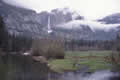 pricier than my frame tent, to the tallest waterfall, Yosemite Falls. This drops around 2400 feet, but technically it’s two waterfalls: the upper falls drop onto a cone of ice that forms at rhe base and then the lower falls reach the valley floor. Further along the road is El Capitan, a 3000 foot cliff, popular with the world’s best climbers. Across the valley is Bridal Veil Falls, maybe the prettiest, but I’d be going there later.
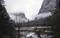
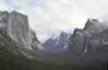
The Merced River flows through the valley and that’s often good for some scenic reflections, but the weather was unpredictable and sometimes the whole valley would disappear as fog or clouds rolled through. My traveling went much faster than I’d expected as the trails around the sights were either closed or impassable because of the snow. However, the snow on the valley floor was melting fast, almost gone by lunchtime. I ended up at the Wawona Tunnel entrance to the valley looking back towards the cliffs and waterfalls.
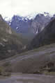 The tunnel emerges onto a typical dome structure, level close to the road but becoming increasingly steep as you move away from it. I think the domes are perhaps Yosemite’s most dangerous feature, as it’s all too easy to walk down the slope, trip and roll, and fall off the dome. On this occasion the dome was also icy so I quickly retreated after taking this picture of distant Bridal Veil Falls.
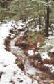
The weather was very changeable, with fog and cloud obscuring the views from there too. I decided that I’d try to get higher up the cliffs to get a better view, and I took off up one of the trails. I don’t remember which one but it looked like some hikers had broken trail through the snow. The only real problem was that the trails turn into streams once the snow starts melting, so I was hiking in a few inches of flowing water, uncomfortable but my feet had been wet all day anyway. I managed to get a few hundred feet above the valley floor before the snow got thigh deep and too difficult for me to see what I was climbing up. As I’d hoped, I was up above the fog and could take some pictures of the view.
 Then I saw this figure plodding up the trail behind me, a guy like me, clutching a camera. We got to talking, and it turned out that he used to be a pilot for Wings West, a company that flew light aircraft between California’s smaller airports. I’d flown on Wings Airline, a similar company that once thrived on carrying passengers from Philadelphia’s airport to its northern suburbs, an alternative to driving the Schuylkill Expressway, known for good reasons as the Sure Kill. The hiker was now a computer salesman, so we had some common background and we probably talked for an hour. During that time we had sunshine, fog, rain, and sleet and we were matching each other with clothing changes. The view up the valley was changing every minute with the weather. After devouring a roll of film each, we walked down to the road together; he was heading back to Sacramento and I decided it would be nice to go and see the giant redwoods in the snow.
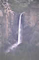
The Mariposa Grove redwoods are at high elevations along the Wawona Road. From the valley, the road climbs further up into the mountains and first arrives at Badger Pass, a ski resort inside the national park. The road had been ploughed up to the resort but no further, so I parked and started walking, but the snow was shoulder deep on the road, and I wasn’t going to make it without snowshoes or skis. By this time I was feeling a bit groggy anyway so I sat in the car and closed my eyes for a nap. When I woke up, it was dark! My first reaction was that I’d wasted the rest of the day by sleeping through it but I soon realized that I now had about four inches of snow on the windshield and it was still snowing, so reluctantly I gave up on the redwoods and returned to the valley floor.
I found the trail to Bridal Veil Falls but lost it again in the snow and ended up walking through the stream. The wind was blowing the spray from the waterfall in all 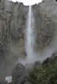 directions so it was like walking in the rain. You can’t get any wetter than wet anyway. Across the valley I had a good view of El Capitan. It was almost dark and I gave up on any further hiking and retreated to Curry Village’s cafeteria.