2013/06 NWT trip - Fort Liard |
|||||
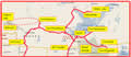 Speaking of which, this is a good point to show our route through the eastern part of the NWT. To give some idea of scale, the map is about 600 miles wide. There are a few tiny places and roads that I haven’t shown, but not many.
This is about all there is.
Sunday June 9th
After some early morning rain, we set off in sunshine along a quite good road, probably a logging “main” that had recently been surfaced. There were also some new-looking side roads off to gas and oil fields, but no signs of habitation, just bog and forest, tiny spruce, and larger birch and cottonwoods.
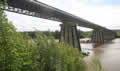
The high bridge over the Fort Nelson River is another matter. It’s what they call an Acrow bridge, one that can be assembled from prefabricated parts in remote areas in a few months without needing expert labour. This one was built about ten years ago and at a thousand feet long it may be the biggest Acrow bridge in the world. It has ripples and tilts and doesn’t look to be straight from any angle, but it’s designed to carry much heavier loads than us.
Later, we took a coffee stop at the Petitot River, a good camping spot if we ever come this way again. Shortly after, we crossed into the North West Territory at the 60th parallel, a thousand miles from Hope, which gives you an idea of the size of the province of BC. The 60th parallel is significant in Canadian geography, as it’s where the provinces end and the Yukon, North West, and Nunavut territories begin. Most of Alaska is north of the 60th too, but the total North American population at those latitudes is quite small. Europe, with its Gulf Stream is very different, with Helsinki and St Petersburg and even Scotland’s Shetland Islands close to the 60th.
The Arctic Circle is at 66º 33´, the point where the midnight sun begins. We couldn’t get that far north on this trip by summer roads in the eastern NWT, so we’d be officially in the “sub-Arctic” for the whole time. Back in 2004 we’d driven up the Dempster highway, NWT 8, from the Klondike to the Arctic Circle and ended up at Inuvik in the western NWT. The eastern and western parts of the NWT are connected by the Mackenzie River, but there’s no summer road, just boats and planes.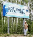
Sandie posed briefly by the NWT welcome sign; briefly, as the official greeters were buzzing around, eager to taste us. The Liard Highway promptly became NWT 7 and changed to gravel, quite good despite its reputation for destroying vehicles. The hamlet of Fort Liard is on a side road; we didn’t need anything but thought we should check it out. It’s an Indian hamlet, a mixture of Dene (Denneh) and Metis, with the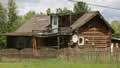 usual big government buildings, including a recreation centre. A lot of the houses were boarded up; some were shacks with tarps on the roof, but others were neat log homes. This one was leaning a little, maybe under the weight of the satellite dish. We were looking for the visitors’ centre, but it was closed and we moved on.